• Discover new ways to elevate your game with the updated DGCourseReview app!
    It's entirely free and enhanced with features shaped by user feedback to ensure your best experience on the course. (App Store or Google Play)

Course Maps

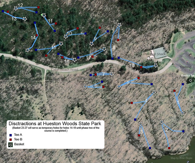
Just finished this one for sadjo:
09f5da44.jpg
 
ok dont laugh toooo hard... but having grown frustrtaed with my courses lack of a map I spent 10 minutes and made this kindergartners map using PAINT

Hey its better than nothing

I also use Paint... due to my lack of skill and/or knowledge of any other way. Here are two different examples of what I've done for the same piece of land. I laid out this course but got turned down when I proposed it. I'll also throw in a Paint tee sign, too, for the proposed course hole #4.

picture.php


picture.php


picture.php
 
great job bill looks great, you had a chance to play chattooga belle yet?

No, it looks very open so we are going to wait until fall when it is cooler and the UV isn't so high...my wife is a vampire.
 
Yeah when he sent me that picture I was like a school girl, not a very common view and the original pic was 6meg and over 4k pixels wide.
 
Yeah when he sent me that picture I was like a school girl, not a very common view and the original pic was 6meg and over 4k pixels wide.

Have you tried a low-angle screenshot for Alex? You might could get one from Bing Maps.

While I'm amazed at Bill's drawing skills in Excel, I have found Open Office to be an excellent alternative to programs that you actually have to pay for.

Let me reiterate that: Open Office is a stable, fully functional office suite that is absolute Freeware and Open Source! And its "Draw" program is pretty nifty too. :clap: :thmbup: :D

If you don't have O.O., there's no reason not to get it, other than maybe saving the HD space.
 
Yeah when he sent me that picture I was like a school girl, not a very common view and the original pic was 6meg and over 4k pixels wide.

The map for Chattooga Belle Farm that Bill did has it's own interesting story.

The owner of this private Pay-to-Play course came by my radio station back in April. I wasn't able to sell him any advertising but he said to me what he wants to do is find something that will draw people to his farm more than the U-Pick fruit operation. A month later, we were designing a course. It went in the ground in July.

A week or two before the course was installed, I asked the owner if he had any aerial photos of the property for mapping purposes. A week later he gave me a disc with hundreds of pics taken from a plane. The one for the map was the best I found on the disc.

Bill did great work.
 
I use Powerpoint (probably similar tools to Excel, but more intuitive IMO.

I think adding a chart with hole lengths is key.....and it keeps things less cluttered on the map. A pet peeve of mine is having numbers and lines so small that you can hardly see them when you print it in black & white (they show up fine on the monitor since they are in color). If you can find a topographic map to use, that adds something too.

Here is a map of I made (the text got a little fuzzy converting to .jpg and shrinking to fit this screen):

attachment.php
 

Attachments

  • Cunniff Topo Map G.jpg
    Cunniff Topo Map G.jpg
    145.8 KB · Views: 43
A course map the City of Seneca, SC, did for their city course was on a topographical map. The city has a mapping department and one of the city employees from the mapping department came out one afternoon, did all the measuring and within a day had a full-color map 18 X 11" and a B&W 2 X 3'.

I liked the map someone did here using Microsoft Paint that looked like a child's coloring page. Wouldn't work on all courses but is perfect for some.
 
You can use a program that does either raster or vector graphics, it doesn't really matter which one you use. If you want to try the Photoshop route, lookup GIMP. It's a free open source program kind of like PS. A vector program like illustrator/in-design would probably be the best, but you can still use raster programs. If you do, set the resolution to 300 dpi if you are going to be printing. Anything less than that won't turn out very well.

If anyone needs some maps made, hit me up, can do some up real quick.
 

Latest posts

Top